Our Innovation Project
Understanding Our Innovation Project
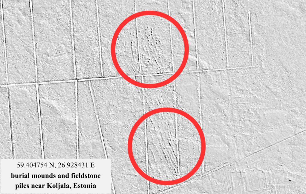
Our innovation project focuses on improving how archaeologists discover potential excavation sites by using artificial intelligence. Currently, analyzing digital elevation maps to identify archaeological objects is a time-consuming process that depends heavily on human experience and can lead to important sites being overlooked.
70% Faster Analysis
AI reduces the time needed to analyze elevation data.
2X More Discoveries
Identifies potential sites that might otherwise be missed.
The UNEARTHED Challenge
Each year the FIRST LEGO League introduces a new theme that challenges teams to explore real-world problems through research, robotics, and innovation.
The 2025–2026 season theme, UNEARTHED, focuses on archaeology and the technologies used to study the past. Teams investigate how historical discoveries are made and develop new ideas that could help archaeologists uncover and understand ancient traces of human activity.
Our team explored how modern technologies such as artificial intelligence and geographic data analysis could support archaeologists in discovering hidden archaeological sites.
The Problem
- Time-consuming analysis
Manually reviewing terrain data takes significant time and effort.
- Subjective results
Findings depend on the experience of the researcher.
- Limited scalability
Analyzing large areas efficiently is difficult.
- Missed discoveries
Important sites may remain undetected.
Our Research
To better understand the problem, we studied how archaeologists work and consulted experts in the field.
#1
To better understand the challenges archaeologists face, we began by researching archaeology and related technologies online. At the start of the season, we explored websites of universities in Estonia that study archaeology and used artificial intelligence tools to gather additional background information about the field.
#2
To gain expert insights, we contacted several archaeologists. One of them, Mairi Kaseorg from the University of Tartu, responded and agreed to meet with us online. During our meeting on December 10, 2025, she explained what a typical archaeologist’s workday looks like and described how archaeological discoveries are documented, measured, and analyzed. She also introduced several challenges archaeologists face, including the difficulty of identifying archaeological sites from landscape data.
#3
To deepen our understanding, we visited the Võrumaa Museum on December 22, 2025, where archaeologist and chief curator Mirja Ots introduced us to archaeological methods used in museums. We learned about typological dating methods, 3D mapping of artifacts, the importance of photography, and how archaeological findings are visualized and presented.
#4
Later we had an online discussion with Marge Konsa on January 14, 2026, who introduced us to the possibilities of using artificial intelligence in archaeology. She explained how AI models can be trained using example images and how machine learning can help identify patterns in archaeological data. We also learned about technologies such as LIDAR scanning, geographic coordinate systems, and tools like total stations and precision GPS.
#5
Finally, on January 30, 2026, we spoke with Maria Smirnova, a researcher specializing in machine learning applications in archaeology. She shared insights into how artificial intelligence can be used to classify historical objects and analyze large datasets. She also explained the importance of well-structured data, large image datasets, and machine learning models such as convolutional neural networks for recognizing patterns in archaeological materials.
Our Solution ArheoScan
Our idea is to develop a concept for an AI-based terrain analysis tool that can automatically detect potential archaeological sites from digital elevation models.
Users would be able to select a region on a map and define search parameters such as elevation differences and distances between terrain features. The AI system would then analyze the terrain data and identify locations that match patterns commonly associated with archaeological structures.
The system would generate a list of coordinates and highlight potential sites on the map, helping archaeologists quickly identify locations that may require further investigation.
How It Works?
The concept for our system follows a simple process:
The user selects a region on a digital map.
Search parameters such as elevation differences and distances are defined.
The AI model analyzes the digital elevation data from X-GIS software of the selected area.
The system identifies patterns that may indicate archaeological structures.
Potential sites are displayed on the map and listed with coordinates.
This approach could significantly reduce the time required for landscape analysis and help researchers focus on the most promising locations.
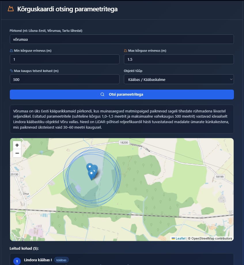
This is our moc-up version of the solution:
Impact
Our solution could help archaeologists analyze large areas more efficiently and systematically.
By supporting researchers in identifying potential archaeological sites, the system could reduce the risk of important locations being overlooked and improve the way archaeological landscapes are studied.
Ultimately, technology like this could help protect and better understand our cultural heritage and the stories hidden beneath the surface of the landscape.
Explore Our Full Project Documentation
If you would like to take a deeper look into our innovation project, you can explore our full documentation. It includes our research process, expert insights, problem analysis, and the development of our AI-based solution.
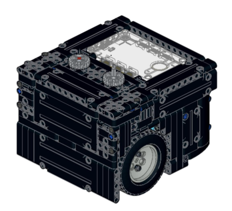
Our Robot Design
Our robot was designed to solve missions on the FIRST LEGO League competition field with precision, efficiency, and reliability. We focused on creating a strong and stable structure while keeping the design flexible enough to adapt to different tasks during the competition.